South Australia
-
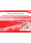
Murray River Access Book No. 14
Waikerie - Cadell - Morgan - Blanchetown. This book includes good mapping (GPS compatible) and…
$10.00
-
Nullarbor Plain Adelaide-Perth CartoGraphics
Nullarbor Plain Adelaide to Perth - Perth to Adelaide This beautifully illustrated map covers the…
$10.00
-
Murray River Access Book No. 15
Blanchetown - Swan Reach - Mannum. This book includes good mapping (GPS compatible) and information…
$10.00
-
Murray River Access Book No. 16
Mannum - Murray Bridge - Tailem Bend - Goolwa - Murray Mouth. This book includes good mapping (GPS…
$10.00
-
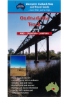
Oodnadatta Track Westprint Map
Marree, Coward Springs, William Creek, Oodnadatta, Marla, Dalhousie springs, Cadney Park, Level Post…
$16.00
-
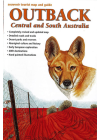
Outback, Central and South Australia Westprint
A desert map for the outback areas of Central and South Australia includes historical information…
$15.00
-
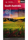
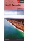
South Australia State Hema
A touring map of South Australia with camping and rest areas, 24-hour fuel and points of…
$15.00
-
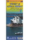
Australia Southeast & Sydney ITMB
This map of Southeast Australia & Sydney by ITMB is double sided. One side @ 1:2,000,000…
$18.00
-
South Australia State Hema Handy
A state map of South Australia reverse side printed with northern half on one side and southern half…
$10.00
-
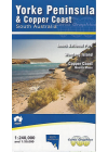
Yorke Peninsula CartoGraphics
A detailed touring map @ 1:350,000 scale of South Australia's Yorke Peninsula of South Australia…
$10.00
-
Murray River Access Book No. 10
Neds Corner - Lindsay Island - Chowilla - Renmark - Paringa. This book includes good mapping (GPS…
$10.00
-
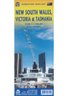
New South Wales, Victoria & Tasmania ITMB
This map bi ITMB @ 1:900,000 is a double sided map of South East Australia covering all of NSW…
$20.00
-
 Sale
Sale
Heysen Trail Old Editions x6
6 Maps as one sale 9 Peters Hill to Barossa Range, 10 Logans Gap to Peters Hill, 11 Newikie Creek to…
$60.00$30.00