 Enlarge
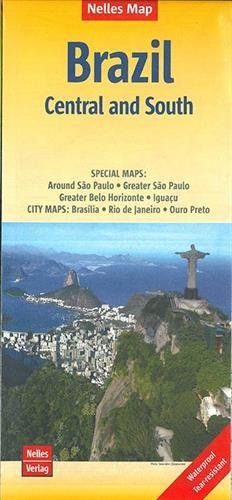
Brazil Central & South Nelles
$20.00
$15.00
Central and southern Brazil @ 1:2,500,000 on a waterproof and tear-resistant map from Nelles Verlag; double-sided, with Rio de Janeiro and São Paulo conveniently included on both sides. Several insets show in greater detail most visited locations, including the Iguaçu Falls, Ouro Prêto and Brasilia.
Relief shading, spot heights and names of mountain ranges present the topography, with graphics for marshland areas. National parks and other protected areas are highlighted. Road network distinguishes between partially paved roads and cart tracks, and shows distances on main routes. Railway lines and local airports are included, and the map also shows internal administrative boundaries with names of the provinces. Various places of interest are prominently marked, including numerous beaches. Latitude and longitude margin ticks are at 2° intervals. The map has no index of localities. Map legend includes English.
Additional panels, all annotated with places of interest, present in greater detail: main traffic arteries and names of districts in Rio including Copacabana and Ipanema, São Paulo, Brasília, Belo Horizonte and Ouro Prêto, plus enlargements of the environs of São Paulo and the Iguaçu Falls area with access from Paraguay, Brazil and Argentina.