 Enlarge
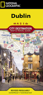
Dublin National Geographic
$20.00
One side of the Dublin map by NGS presents a detailed road network with designations for through routes, main and secondary roads, one way streets and pedestrian areas. It features hundreds of points of interest, displayed with a multi-language legend, including metro and train stations, hotels, parks, hospitals, police stations, places of worship, theaters and monuments. Many top attractions are depicted in 3D, such as the Dublin Castle, National Museum and St. Patrick's Cathedral.
The reverse side has maps of the entire island of Ireland, the region and the Phoenix Park area as well as descriptions of the city and many popular attractions. A user-friendly index of streets, hotels, parks, public buildings and other points of interest is included, along with a rail map, diagram of Dublin airport and overview of the transit system, helping you to plan your route.
Printed on durable synthetic paper, making it waterproof, tear-resistant and tough — capable of withstanding the rigors of international travel.