 Enlarge
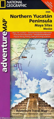
Northern Yucatan Penisula National Geographic Adventure
$20.00
NGS' Yucatan Peninsula map is a complete travel guide to the region, covering the area of Campeche to the Caribbean Sea and Gulf of Mexico shorelines, including the Riviera Maya. One side presents hundreds of points of interest, a detailed road network and topographic features, along with inset maps of the cities Merida and Cancun. While the reverse side provides maps and valuable information of the Maya ruins at Chichen Itza, Ek Balam, Tulum, San Gervasio, Coba, El Rey and Uxmal.
A user-friendly index of federal, state and municipal protected areas, such as Isla Mujeres, Yum Balam and Cozumel, will help you plan your journey. Then, you can plan your route with the mapped road network which includes major roads as well as dirt and gravel roads, for those wishing to travel off the beaten path. Additional transportation features mapped include airstrips, ferry routes, railroads and harbors. Also included are cultural, historical, ecological and adventure points of interest, such as UNESCO World Heritage Sites, Maya sites, ruins, lighthouses, beaches, reefs and areas for surfing, kayaking, sailing, wind surfing, snorkeling, diving and fishing.
Printed on durable synthetic paper, making it waterproof, tear-resistant and tough — capable of withstanding the rigors of international travel.